As mentioned in my previous post, we were very unlucky with
the weather and the ice conditions on our voyage to the Ross Sea in Antarctica.
Whether this is the result of climate change or not, I wouldn’t like to venture
a guess, but certainly we ran into terrible conditions---howling gales,
mountainous seas, leaden skies and worst of all pack ice blocking the entrance
to the Ross Sea requiring us to travel hundreds of miles out of our way to find
a break in the pack. I now have an idea
of how frustrating and bored the sailors in those early expeditions must have
been---and also why no more than two or three tourist ships even try to get
this far each year.
After travelling through the pack ice in 24 hour daylight
for days we finally broke through into the open water of the Ross Sea. I had
not realised how huge the Ross Sea is. On a map of Antarctica it looks like no
more than a large indentation in perimeter of Antarctica, but the sea is actually
the size of southern Europe. It is partly covered by a permanent cover of ice
called the Ross Ice Shelf which is the size of France---490,000 square kilometres
and up to 750 metres thick! I never cease to marvel at the size of Antarctica.
The rest of the Ross Sea is covered in sea ice in the Antarctic winter but the
entrance to the sea is supposed to be free of ice at this time of year. Not
this year though!
However even though we were in open water now, the bad weather
did not let up and it was rough and windy and visibility was poor as we made
our way over the course of the next couple of days deeper into the Ross Sea to
Ross Island, which is attached to the edge of the permanent ice shelf. In fact although the
land mass of Ross Island is separated under the ice from the mainland, since
the ice shelf is permanent it is usually considered to be part of Antarctica
itself.
As we approached Ross Island we also had a fine view of the
Trans-Antarctic Mountains on the mainland of Antarctica beyond the Ross Ice
Shelf. These mountains shimmered enticingly on the horizon reminding us that
although we had come so far we still had not even reached the mainland of the
continent!
As we approached Ross
Island we saw a brighter haze in the sky above the fog-bound coastline. That
was all we got to see of Mount Erebus, the most southerly active volcano on
earth at 3794 metres. It is part of the Pacific Ring of Fire. It is hard to
believe that an active volcano spews molten lava and ash amidst all this ice,
but it does, and has been continuously active since 1972. Ross Island is also
home to three other volcanoes the largest of which is Mount Terror at 3262
metres, but these three are inactive.
Of course the extremely cold temperature
ensures that the lava and gases cool before reaching the coast below, but the
whole island is covered in gritty black lava mixed with snow and the fierce wind
blows tiny grains of sharp black lava into your face all the time as you
struggle to walk.
Ross Island is where Robert Falcon Scott had his base camp
on his fateful and fatal 1910 to 1912 expedition to reach the South Pole. As
you will all know he was beaten by a month to the South Pole by Roald Amundsen
and then got caught in a blizzard on his return journey and died with all his
companions in March 1912. History has swung back and forth as to whether Scott
was a tragic hero or an inflexible pompous British naval officer unwilling to entertain 'foreign' ideas like skiis and sled dogs (which were used so successfully by the
Norwegian Roald Amundsen to make his journey to the South Pole with ease).
What is not in doubt
is that in this, the so called “Heroic Age of Exploration”, people undertook
extraordinary challenges and bore extraordinary privations, driven not by money
but by the ideals of the time. In our more practical age we probably would consider them mad, but that doesn't stop the modern day adventurers endeavouring to retrace their steps--but with all mod cons.
And those
men who took part in these early twentieth century expeditions then returned to a Europe caught up in
the First World War. On their return from several years in nature’s most
inhospitable continent, many of them headed straight off for the man-made
horrors of the trenches of France.
We managed to get ashore on the zodiacs to visit Scott's Hut,
which has been carefully restored by the Antarctic Heritage Trust. It was a fascinating
time capsule (see photos below). It was actually quite spacious and they had many of the comforts of the time, but as you approach it from the sea it looks so little, brave and foolhardy, sitting there in its small cove
surrounded by a gigantic monochrome world—shades of black, grey and white. And the gods put on the proper weather for our arrival:it
was very very cold and very very windy. Temperature was minus 10 degrees C but a
wind chill of minus 25 degrees C. When you climbed out of the shelter of the cove you were blown backwards by the blasts of wind.
We had hoped that we would also be able to land later the
same day at Ernest Shackleton’s hut from his 1909 expedition, which is a mile or two further
up the coast of Ross Island, but the conditions were too fierce, and dangerous sea
ice was blocking the landing place. Actually I think a lot of people were
secretly glad that we couldn’t go ashore since we were all so cold from our
visit to Scott’s hut!
And so we sailed back through the Ross Sea and spent
another few days in the pack ice (we did have one excellent zodiac excursion in
the pack ice—see photos).
However, we did have one more surprise though and that was a sail-past of
Scott Island. This island is very remote and was only discovered in 1902 and
mapped in the 1960s. Almost no one goes near it since it is in the middle of
the Southern Ocean far from the edges of the Ross Sea, but because we had had
to come so far out of our way through the pack ice in order to enter the Ross
Sea, we came very close to Scott Island. None of the expedition team or the
captain had ever been there before and in fact the charts the ship had showed
it to be in a different place! So much for the maps of the 1960s! It was an
extraordinary sight—a plateau uplifted 55 metres above the sea and with an
extraordinary black pillar of volcanic origin (Haggitt’s Pillar) a few hundred metres
off its shore, and the surrounding sea 3000 metres deep.
And then the long sea journey back towards New Zealand. The
mountainous seas and high winds continued and it was often impossible to go out
on deck. We certainly got to experience what Antarctica can throw at puny human
beings who dare to approach its shores.
We did land on Campbell Island, one of the New Zealand
sub-Antarctic Islands but I’ll do a separate post for that.
 |
| This and the following few photos do not look like much but they are the Trans-Antarctic Mountains on the mainland of Antarctica nearly a hundred miles away.These mountains divide Antarctica into East and West, which as mentioned in my previous post are very very different geologically and climatically. In order to reach the South Pole you need to cross not only the Ross Ice Shelf but also these mountains. |
 |
| You can see from this photo the monochrome colouring of Antarctica on a stormy and overcast day. And then another day there will be brilliant sunshine and the many shades of blues and whites and pale pinks and pale yellows will make it seem like a different place. |
 |
As you can see the Trans-Antarctic Mountains are not all snow covered. This is not because they are not cold. It is because they are "dry". They existed before Antarctica spit from the rest of Gondwana and drifted southwards and became ice covered, and because they are so high they formed a barrier to glaciers which were not able to penetrate
them to slide down the valleys and into the Ross Sea. |
In this photo you can see glaciers sweeping around the edge of one of the Trans-Antarctic Mountains
 |
| me getting ready for our landing on Ross Island. Note the glow of the active volcano, Mount Erebus, behind the clouds. |
 |
| Scott's Hut on Cape Adare from his fatal 1910-1912 expedition |
 |
| A lone penguin looks out to into the sea where our ship waits for us. See the Trans-Antarctic mountains on the horizon |
 |
| Scott's hut. Note the privy at the rear. the lower extension is the stables where the ponies and dogs were kept. For some reason Scott decided that Manchurian ponies would be good beasts to haul the sledges. They were useless. The dogs were better but Scott refused to use them to their full potential and preferred that he and his men would "man-haul" the sledges themselves! |
 |
| The ward room table. You have probably seen the old photos of Scott and his officers sitting around this table |
 |
| And again---the bunks are behind |
 |
| Scott maintained the British naval separation of "officers" and "men" and this was the "men's" table separated from the officers section of the hut by a wall of packing crates |
 |
| This was Herbert Ponting's darkroom where he developed the historic photos we have all seen. Having a photographer along on the expedition was an innovation of Scott's |
 |
| This is Dr Wilson's lab where he analysed the specimens collected. Part of Scott's mission was to collect scientific samples |
 |
| A set of bunks which was the only private space each man had |
 |
| These are the beds of the senior officers. On the table in the foreground is a freeze-fried emperor penguin |
 |
| This was Scott's cubicle and work-table in the foreground |
 |
| The cast iron kitchen range. Note the cannister of Lipton's tea |
 |
| A wall of crates containing supplies. Some still-familiar names on the tins and crates |
 |
| The sewing supplies |
 |
| A pile of seal blubber in the stables--used for heating |
 |
| The skeleton of one of the dogs |
 |
| The rear of the stables with sacks of food for the ponies. Sledge runners leaning against the wall at left |
 |
| The cove and hut as seen from the large cross at the top of a small hill. note the monochrome colours and the black lava grit . See too the glow from Mount Erebus above the clouds |
 |
| Me trying to shelter myself from the biting sharp wind |
 |
| View away from the hut towards McMurdo Sound where the US base is |
 |
| Me beside the memorial cross which overlooks the cove where the hut is |
 |
| The lava-strewn coast of Cape Royds where Shackleton's hut can just be seen in the centre of the photo |
ZODIAC CRUISE THROUGH THE PACK ICE
 |
| Adele penguins on a flow as we approach |
 |
| A Crabeater seal perched on a flow |
 |
| This shows the vast amount of ice under the water at the base of a berg. That is why a ship needs to be so careful going through the pack ice |
 |
| A Crabeater swimming away as our zodiac approaches |
 |
| The zodiacs cruising through the pack ice |
 |
| The dirty yellow on the lower edge of this berg is a lichen which grows on the older ice. You can sometimes see the krill (the minute shrimps which are the food source for most of the Antarctic mammals) feed on this algae |
 |
| another piece of pack ice, probably several years old |
 |
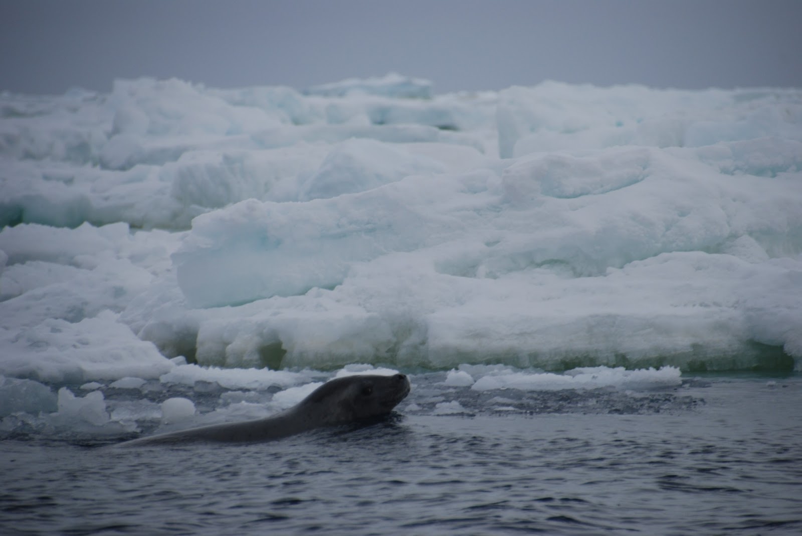
| A Weddell seal wonders why this zodiac with these strange red penguins is bothering him |
 |
| A lump of pack ice in our zodiac .... |
 |
| ...and the same ice being put to good use for drinks back on board |
 |
| The extraordinary Scott Island and Haggitt's Pillar (see explanation above) |
 |
| Passing to the side of Scott Island and Haggitt's Pillar |


No comments:
Post a Comment